


Places along the way:
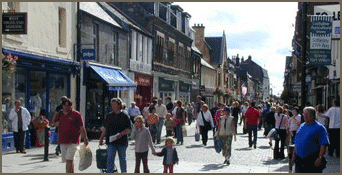 Fort
William High Street
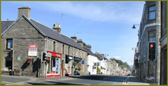
Fort
William High Street
Fort William
Fort William (Scottish Gaelic: An Gearasdan, "The Garrison"
is the largest town in the highlands of Scotland and second largest
settlement behind the city of Inverness.
Fort William is a major tourist centre with Glen
Coe just to the south, and Glenfinnan
to the west, on the Road to the Isles. It is an
important centre for hillwalking and climbing due to its proximity to
Ben
Nevis and many other Munro mountains, marketing itself as the
"Outdoor
Capital of the UK". It is also well known for its nearby famous
Downhill Mountain Bike Track at the Nevis
Range and its
connection to the West
Highland Way from Glasgow and the Great
Glen Way; a walk/cycle way from Inverness to Fort William through
the Great
Glen. (Check out amenities in Fort William)
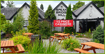 Spean Bridge Mill
Spean Bridge
Spean
Bridge (Scottish Gaelic: Drochaid Aonachain) is a settlement in
Glen Spean at the northern side of Ban Nevis.
The village takes its name from the bridge over the River Spean on General
Wade's military road between Fort William and Fort
Augustus, and not from Telford's bridge of 1819 which carries the A82
over the river at the heart of the village.
Lying in the Great Glen, Spean Bridge has transport links north towards
Inverness and south to Fort William, provided by the A82, and
the A86 heads east to join the A9 at Kingussie.
The village is served by the Spean Bridge railway station providing
links to London, and
between 1903 and 1933 it offered a branch line service to Fort
Augustus. (Check out amenities in Spean
Bridge)
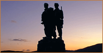 Commando
Memorial
Commando
Memorial
Commando Memorial
Based at Achnacarry,
Commandos
and United States Army Rangers were trained in the area around the village
between 1942 and
1945.
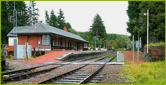 Tulloch Station Bunkhouse
Tulloch railway station
is a rural railway station in the Highland region of Scotland. This
station is on the West Highland Line, 169 kilometres (105 mi) north
of
Glasgow Queen Street.
The station was laid out with two platforms, one on either side of a
crossing loop. There are sidings on the north side of the station.
The station buildings are now used as a hostel. (Check out amenities
in Tulloch)
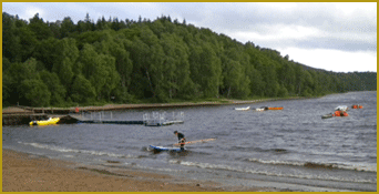
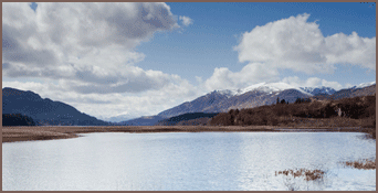 Loch Laggan, view west
Loch Laggan
Loch Laggan is a freshwater loch situated east of Fort William, in Lochaber,
Highland, Scotland. The A86 road from Spean Bridge to
Kingussie follows along its north bank. Since 1934 Loch Laggan has been
a reservoir, retained behind the Laggan
Dam, forming part of
the Lochaber hydro-electric scheme.
The Loch featured in the popular BBC series Monarch
of the Glen as Loch Bogle, and the Eastern end of the Loch includes
the largest
freshwater beach in the UK.
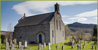 Laggan Churchyard
Laggan Village
Laggan (Gaelic: Lagan) is a village in Badenoch,
in the Highland region of Scotland. It is beside the River
Spey, about 10 km west of
Newtonmore. The A86 road passes through
the village and crosses the river on a nearby bridge. It is notable
as being the region in
Badenoch where the Gaelic language survived the longest.
Laggan is in the Cairngorms
National Park and featured as the fictional village of Glenbogle
in the BBC TV drama series Monarch
of the
Glen where many of the locals took part in playing the minor background
roles.
Nearby
Visitor attractions include:
- Ruins of a Pictish
fort near Strathmashie, Laggan.
- The Laggan Wolftrax,
a mountain biking centre located in the nearby Strathmashie Forest,
opened in 2004. This facility, owned by the
Forestry Commission, features over 17 kilometres (11 mi) of purpose-built
trails.
- Pottery
Coffee Shop and Bunkhouse, on the A889 road between Dalwhinnie and
Laggan offers Homely Bunkhouse and Great
Home-baked cafe. Lounge Overlooking Hill, Woodstove, Hot-tub on deck"
Peter Irvine, "Scotland the Best" 2008.
- Horse Riding and Pony Trekking: The popular outdoor sport of Pony
Trekking was credited with being started in Badenoch at nearby
Newtonmore in 1952 by Ewan Ormiston, it is still possible to ride in
Newtonmore with his grandson Ruaridh at the Newtonmore Riding
Centre. (Check out amenities in Laggan)
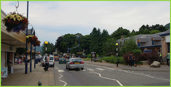
 Newtonmore
Main Street
Newtonmore
Main Street
Newtonmore
(Scottish Gaelic: Baile Ùr an t-Slèibh) is a village in
the Highland council area of Scotland. It has a population of about
1000.
Nestling above the flood plain of the River Spey, in Britain's largest
National Park - The Cairngorms, with a backdrop of the Monadhliath
Mountains, Newtonmore is surrounded by woodland. Larch, Pine, Birch
and Alder predominate, creating a glorious tapestry of colour as
the leaves turn in Autumn. Newtonmore's 'Wildcat Trail' is a 10km orbital
walk around the edge of the village, taking in the River Spey
and its tributary, the Calder - rivers of very different character -
woodland and moorland, together with wonderful views across the strath
to the Cairngorms and behind the village to the Monadhliath mountains
- a fitting introduction to the delights of the National
Park. (Check out amenities in Newtonmore)
 Kingussie
High Street
Kingussie
High Street
Kingussie
The name "Kingussie" comes from the Gaelic, "Ceann a'
Ghiuthsaich" which means "Head of the Pine forest".
The ruins of the early 18th century Ruthven Barracks (Historic Scotland;
open to visitors at all times) lie near the original site of the
village which was moved to avoid the flood plain of the River Spey.
The Hanoverian Barracks were built on the site of Ruthven Castle,
the seat of the Comyns, Lords of Badenoch in the Middle Ages. (Check
out amenities in Kingussie)
 Loch
Insh
Loch
Insh
Kincraig
(Scottish Gaelic: Ceann na Creige) is a village located north of Kingussie
and south of Aviemore in Highland, Scotland. The village lies
at the side of the former A9 road and 100 metres away from the current
A9. It has a shop, post office, pub, watersports centre and
village hall. (Check out amenities in Kincraig)
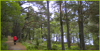 Loch an Eilein
Rothiemurchus Forest
The forest is popular for recreation, but contains some of the most
important wildlife in Europe, including the osprey, Scottish crossbill,
capercaillie, crested tit and wild cat.
Stretching from the River Spey to the high mountain plateau, Rothiemurchus
forms one of the most treasured areas of the Cairngorms
National Park. Its natural splendour of forest, loch, glen and mountain
has attracted visitors for centuries.
A living Highland estate in the ownership of the Grant family since
the 16th century, it is cared for today by Johnnie Grant, 14th Laird,
his wife Philippa and their family.
 Aviemore
Aviemore
Aviemore (Scottish Gaelic: An Aghaidh Mhòr) is a town and tourist
resort, situated within the Cairngorms National Park in the
Highlands of Scotland. It is in the Badenoch and Strathspey committee
area, within the Highland council area. Prior to 1890 it was in
an exclave of the county of Moray and from 1890 to 1975 it was in the
county of Inverness-shire, until the latter date being within the
Civil Parish of Duthil and Rothiemurchus. The town is popular for skiing
and other winter sports, and for hill-walking in the Cairngorm
Mountains. The Aviemore stone circle is located within a residential
neighbourhood of the town. (Check out Aviemore
amenities)
Text is available under the Creative
Commons Attribution-ShareAlike License; additional terms may apply.
See Terms
of Use for
details.
Wikipedia® is a registered trademark of the Wikimedia
Foundation, Inc., a non-profit organization.